Headwaters & Prairie Creek Reservoir Region
This region encompasses the subwatersheds of Buck Creek, Muncie Creek, and the Killbuck Creek headwaters, along with Prairie Creek Reservoir. It includes the cities and towns of Muncie, Yorktown, Winchester, and Daleville. The region had a total population of 112,356 according to the 2020 US Census Bureau. The population breakdown indicates that 84% of the residents identify as White, 7% as Black, 3% as Hispanic, and 17% as a person of color.
Notable employers include Ball State University, IU Health Ball Hospital, and Muncie Community Schools.
Significant water usage in the region is primarily driven by public water supply companies like Indiana-American Water. Various additional industries, including Irving Bros. Stone and Gravel and Sagamore Ready Mix LLC, are also major water users in the region. An assessment of streams in the region revealed that 91% of evaluated waterways do not meet State water quality standards, indicating the need for water quality improvement efforts.
Regarding land use, open water accounts for 0.9% of the region’s land area. Developed land comprises 15.6%, while natural land (forest, wetlands, shrubland) covers 10.1%. Much of the land, approximately 73.4%, is utilized for agricultural purposes, reflecting the significance of agriculture in the region’s economy and landscape.
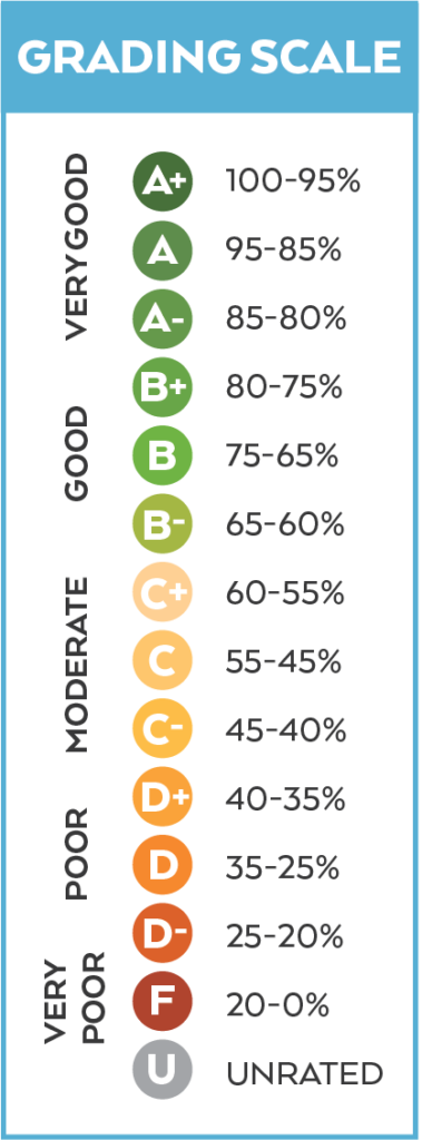
This region has an overall score of 47%, a C.

Photo Credit: Kyle Johnson
By category, the region has a D+ (39%) in Community, C- (44%) in Land, and C+ (59%) in Water. The lowest scoring indicators are Wetland Change and Voter Participation with failing (F) scores in each. The highest scoring indicators are Education, Nutrients (levels in the water), and Aquatic Life, all with a B.


Highest Scores: Education, Nutrients, Aquatic Life

Lowest Scores: Wetland Change, Voter Participation

